
The warming climate expands oceans and melts polar ice. Sea level has been rising at a rate of about 3.3 mm per year for the last 20 years (BOM and CSIRO 2014).

Sea level is expected to continue to rise with further global climate warming. The upper range of projections from the Climate Futures for Tasmania modelling indicates a rise of 0.82 metres for Tasmania by 2100.
Though this doesn’t sound like much, for every metre of sea level rise about 100 – 200 metres of shoreline is lost from the land.
Storm surge, wind, waves, tide and sea level combine to cause coastal erosion and flooding from the sea, which is called inundation. The current once in a 100-year storm surge and high tide is likely to become more frequent.
For people who live near the coast there are hazards. The sea is already claiming gardens and fences. In some places in the world it is already claiming houses. Insurance companies are refusing to insure houses in high risk areas. For other property owners, the cost of insurance is increasing rapidly.
Research from leading climate risk analysts shows the number of houses in Australia that insurance companies will refuse to insure could be 1 in 20 by the turn of the century, if nothing is done to address escalating risk from extreme weather and climate change.
There are areas at a high level of risk for coastal inundation and erosion in the Clarence municipality. Clarence City Council has informed the community about this risk.
Different pathways for adapting to these changes were explored with the community, ranging from ‘early retreat’ to ‘protect at all costs’. This helps with planning for projected changes.
You can read all the reports produced HERE
Protecting property on the coast costs a LOT of money. Estimates for building a sand collecting structure (a groyne) at Roches Beach indicated costs of several million dollars. More importantly any modification of the shoreline results in new problems. The coast is a very dynamic natural system with many forces and processes interacting with each other. Any shoreline modification is very likely to shift the erosion threat along the coast or even have unforeseen consequences.
Risk management for coastal communities
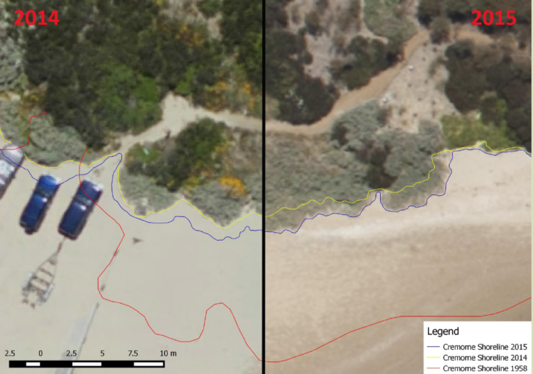
Clarence City Council has taken a leading role in responding to the risks of climate change on the coast. Scientists from consulting company Water Research Laboratory used complex climate modelling on a local scale to produce coastal maps showing possible sea level rise and shoreline location.
Sea level rise is referred to in Clarence’s planning documents and factored into planning decisions.